


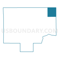
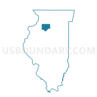
CLARION Voting District, Bureau County, Illinois
About
Outline

Summary
| Unique Area Identifier | 564618 |
| Name | CLARION Voting District |
| County | Bureau County |
| State | Illinois |
| Area (square miles) | 35.35 |
| Land Area (square miles) | 35.35 |
| Water Area (square miles) | 0.00 |
| % of Land Area | 100.00 |
| % of Water Area | 0.00 |
| Latitude of the Internal Point | 41.54038120 |
| Longtitude of the Internal Point | -89.22156300 |
Maps

Graphs
Select a template below for downloading or customizing gragh for CLARION Voting District, Bureau County, Illinois


Neighbors
Neighoring Voting District (by Name) Neighboring Voting District on the Map
- BERLIN Voting District, Bureau County, IL
- LAMOILLE NO 1 Voting District, Bureau County, IL
- MENDOTA 2 Voting District, LaSalle County, IL
- MENDOTA 6 Voting District, LaSalle County, IL
- MENDOTA 7 Voting District, LaSalle County, IL
- SUBLETTE Voting District, Lee County, IL
- TROY GROVE 1 Voting District, LaSalle County, IL
- TROY GROVE 2 Voting District, LaSalle County, IL
- WESTFIELD NO 1 Voting District, Bureau County, IL
Top 10 Neighboring County Subdivision (by Population) Neighboring County Subdivision on the Map
- Mendota township, LaSalle County, IL (7,534)
- Troy Grove township, LaSalle County, IL (1,333)
- La Moille township, Bureau County, IL (1,122)
- Westfield township, Bureau County, IL (941)
- Sublette township, Lee County, IL (776)
- Berlin township, Bureau County, IL (746)
- Clarion township, Bureau County, IL (421)
Top 10 Neighboring Place (by Population) Neighboring Place on the Map
Top 10 Neighboring Elementary School District (by Population) Neighboring Elementary School District on the Map
Top 10 Neighboring Secondary School District (by Population) Neighboring Secondary School District on the Map
Top 10 Neighboring Unified School District (by Population) Neighboring Unified School District on the Map
- Amboy Community Unit School District 272, IL (5,261)
- La Moille Community Unit School District 303, IL (1,769)
Top 10 Neighboring State Legislative District Lower Chamber (by Population) Neighboring State Legislative District Lower Chamber on the Map
Top 10 Neighboring State Legislative District Upper Chamber (by Population) Neighboring State Legislative District Upper Chamber on the Map
Top 10 Neighboring 111th Congressional District (by Population) Neighboring 111th Congressional District on the Map
Top 10 Neighboring Census Tract (by Population) Neighboring Census Tract on the Map
- Census Tract 9621, LaSalle County, IL (5,107)
- Census Tract 9619, LaSalle County, IL (4,355)
- Census Tract 9650, Bureau County, IL (4,078)
- Census Tract 8, Lee County, IL (3,767)
- Census Tract 9, Lee County, IL (3,557)
- Census Tract 9647, Bureau County, IL (3,072)